Many of us love to travel, discover new places, get a lot of bright and unforgettable impressions from an exciting trip. At the same time, we do not always have the opportunity to go where we would like to, walk through the streets of beautiful cities and enjoy all the wonderful flavor of those places. Google responded to these users by launching an online service in 2007 that allows them to take a virtual journey through the streets of many cities around the world. In this article I will talk about the Google Maps Street View service, explain how to use it, and perform an online inspection of streets and houses.
Google Street View - Google Maps Street View
"Google Street View" (Google StreetView) is a technology based on the work of Google Maps (Google Maps) and Google Earth (Google Earth) services that allows you to view panoramas of the streets of many cities around the world.
The service was launched in 2007, and initially included photos of some US cities. Now, its capabilities allow you to enjoy the panorama of the streets of many cities of the Old and New Worlds.
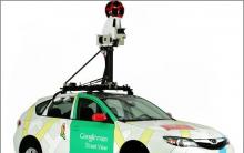
The creation of such panoramas is usually carried out with the help of a specialized vehicle, on which a spherical camera is placed, which performs continuous 360-degree shooting.

The photos obtained in this way are processed by Google and placed on the specified service, allowing you to construct breathtaking panoramas of the streets of many cities around the world.
And although most of the photos are taken with a car, there are many photos taken by a pedestrian, a trekker, a tricycle, a snowmobile, an all-terrain vehicle, a boat, and even submersibles.
 When instead of a car - a pedestrian
 How to See Streets and Houses on Google Maps
To view streets using Google services, you can use both the stationary Google Maps network service and the capabilities of the Google Street View mobile application.
To perform a street view of a city (take, for example, the city of Moscow) do the following:
- Launch the Google Maps service using your PC's browser (you can also simply enter the name of the city and the desired street in the Google search box, you will be offered to view this place on Google maps);
- Find the city you need on the map (enter its name and street in the search bar, or find the city you need by moving the map and zooming accordingly using the mouse wheel);

- Find the street you need, and then click on any of its places (a marker will appear there). Now select a small photo of this street at the bottom of the screen, and you will switch to the view mode of this street;

- To activate the street view mode, you can also select the little man icon on the right, and, holding the left mouse button, drag it to the street we need;

- To move along the street, move the cursor to the desired place on the street, and press the left mouse button. Those places where you can move are indicated by the "X" icon. At the same time, the arrows behind and in front of you show that you can move in the indicated directions;

- By holding the left mouse button and moving the mouse in the right direction, you can look around and admire the local sights (you can also use the "+" and "-" keys next to the icon on the right to zoom in and out);
- To return to the general view of the city, click on the back arrow on the top left.
Is it possible to see the streets in Google in real time
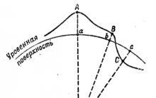
Many users would like to enjoy a real-time view of their desired streets and cities using services like Google Maps. Unfortunately, it is not possible to implement this at the moment (with the exception of those places where cameras are installed), since Google, Yandex, and their competitors card services use photographs taken weeks, months, or even years ago.
The actual implementation of such tasks would require the use of many satellites, which, at the moment, are used primarily for military purposes.

Conclusion
In this article, I described the specifics of using the Google Maps service for street view. This service can be useful for getting to know the sights of various cities of the world, for building optimal routes and solving other similar problems. Take a virtual trip to various cities of the world, and you may want to personally go to the place you like in order to fully enjoy its amazing beauty. After all, it's worth it.
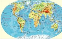
Google Maps is one of the most popular services today. It provides users with the opportunity to observe our planet (and not only) from a satellite online at high quality and in real time (the sights of the planet in). At some point, after all, the championship of the schematic map view was intercepted by the Open Street Maps application. Where everyone in the know can edit a Wikipedia-style map, but this does not change anything, and today Google Maps is the most popular online map service. The popularity of the cards of this company has been in the first place for many years due to the good quality of satellite images in any corner of the planet, even Yandex could not provide such quality in its homeland.
Google Maps Online
Quality of Google Maps satellite images in 2020
Google continues to improve its brainchild in the form of visualization of our planet, improving the quality and detail of surfaces. More recently, the company has improved its services using the new Landsat 8 satellite, which can photograph the surface of the planet Earth with a resolution of 15/30/100 meters per elementary point. The real-time satellite imagery database was only updated in 2013 before. At that time, the application used images taken by the Landsat 7 satellite, which is also known for introducing some bugs and crashes into the maps. To compare the quality of images taken by different satellites, pay attention to the screen below.

Images taken by different satellites
In the examples on the screen, you can see that the image of the new satellite shows not only improved detail of terrestrial objects, but also more natural colors. Google representatives announced that about 700 trillion pixels of graphic data have been spent on collecting a new generation of mosaics of the earth's surface. Almost 43 thousand of the most powerful computers in the Google cloud worked for a week on gluing pictures.
How to use Google Maps online
You can use Google Maps online in high quality anywhere in the world using your tablet, mobile phone or computer. Just follow the link https://google.com/maps/ or use the built-in map below and you can find the country, city and even the way to the museum by specifying the desired search parameters. And for mobile devices, you can download a special application that is more convenient to use.
To find your way to a laundromat or cafe that you often visit - just enter the addresses in the program line and you will no longer need to enter this data every time. At the same time, you can not only view the paved road to the institution, but also get acquainted with the information that relates to this institution, for example, opening hours, contact details, etc.
Let's use an example to use a map from Google from satellite 2020.
- Go to the website or open the app on your mobile device.
- You just need to point with the cursor or touch on the touch screen, and you can view the details of this area.
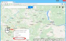
- In order to find out the distance between cities, right-click on one of them and select "Measure distance" from the drop-down menu. Now the second point can be specified with the left mouse button. If necessary, the point can be dragged with the mouse to another location, the distance information will be updated.
- To select the mode "Relief", "Bicycle paths", "Traffic jams" - select the menu sign (three bars) and press the desired option. If you are using Apple devices, click on the diamond icon with the layer and also on the desired option.
- To take advantage of high quality 3D images, click on the square in the lower left corner. It will say "Satellite", if you need to return to map mode, press it again.
- To select the Street View mode, drag the yellow man to the desired area of the map, or simply enter the exact location in the query bar, preferably with a home address.
- High-resolution Google Maps allows you to view streets in historical mode, i.e. how they have changed over time. To do this, throw the little man on the right place on the map. Select the clock icon and move the time slider to select the desired date.
Surprising Facts About Google Maps

Features and benefits of online maps in real time
From the first days of Google Maps have become a discovery for all users. They made it possible to look at the cards in a new way, to pay attention to this instrument in a new way. Everyone who accessed the Internet back in 2005 sought to immediately use online maps and see their city or country from a satellite.
It seems unthinkable, but today it is possible to view other planets of the solar system in the Google Maps application!

Planets in Google Maps
To do this, go to the web version of the program and move the image of the Earth to the maximum with the mouse wheel. Other planets will appear on the left in the block, which you can select to view. There are all the planets of the solar system and a few more of their satellites. For example, Callisto is a moon of Jupiter. True, the pictures do not allow us to view other planets as closely and in detail as it happens with the Earth.
Google maps from satellite in 2019 will allow you to view the surface of the earth and settlements in excellent quality, which cannot be done using a regular map. When compiling paper and other versions of maps, natural colors, clear contours of the banks of rivers, lakes, coloring of land areas and other color schemes are omitted, which is why we have poor orientation. Looking at the desert area on a regular map, one can only guess what kind of vegetation or terrain is there. Turning to Google Maps in real time, you can even see the color and shape of the fence at any address on another continent.
5 weird places you can see on Google Maps
Google Maps Service (Google Maps) is one of the most powerful mapping services in the world. Its capabilities allow you to enjoy satellite images of the surface of our planet. You can also use the capabilities of an interactive map, easily build a convenient route from point A to point B, get up-to-date information about traffic jams, and much more. At the same time, not all users are fully familiar with the capabilities of this service, which in a certain way prevents its full use. This material is designed to eliminate such "white spots", in which I will talk about Google maps, which are available online in real time and in excellent quality, and explain in detail how to use their capabilities.
We study the functionality of the online service "Google Maps"Capabilities of the map service Google Maps
"Google Maps" is a web service that provides detailed visual information about geographic regions and places around the world. In addition to displaying a conventional road map, the service also offers aerial and satellite imagery of various locations, and there are images taken from various vehicles.
 This is what the Google Maps start screen looks like.
 Google Map includes several popular services:
- The route planner offers the creation of routes for drivers and pedestrians who want to get from point A to point B;
- The Google Maps API makes it possible to embed maps from Google maps on various sites;
- Google Street View (Google StreetView) allows users to view the streets of various cities of the world, virtually moving through them;
- Google Maps for mobile platforms offers the use of GPS navigation of mobile devices to position the user on the map;
- Auxiliary services offer images of the Moon, Mars, clouds, and so on. for astronomers and just amateurs.
To start working with Google maps in full screen, launch the service google.com/maps. You will see a schematic map of the world (depending on the user's location, usually a map of Europe).
Instructions for using the map from Google
The Google Maps service interface looks like this:

Additional options in the Menu item
Also in the Google Maps menu bar, which opens by pressing the menu button at the top left, the following useful options are presented:
- « Satellite» - Switches to photographic map display mode, created using satellite photos. Pressing this option again switches the map back to schematic mode;
- « Traffic jams» - shows current traffic jams in major cities. The color gradation from green to red shows the speed of traffic in the specified traffic jams;
- « Transport» - allows you to display the schematics of public transport in the right place;
- « Relief» – allows you to display the terrain of the area
- « Transfer of geodata» - allows people to follow the location of each other using Google Maps;
- « My places» - allows you to move between the places you added in the Google Maps service;
- « Your impressions» - allows you to add some textual impression about any of the places on the map (as well as attach a photo of this place).
Activate Google Maps Satellite View
Displaying Google maps using satellite photos is one of the most popular forms of working with the Google Maps service. It allows you to enjoy the view of the desired geographical location, created using satellite images, as well as images from special devices operating at a bird's eye view (from 240 to 460 meters).
The received photographs are regularly updated (their age is no more than 3 years). They enable each user to enjoy the view of the desired places from the satellite, visually pave the most convenient road from one place to another, and so on.

Google Earth - allows you to enjoy high-resolution images
Among the features of the Google Maps service is the Google Earth service. In addition to the technology of the already well-known satellite mapping of the surface of the globe, Google Earth allows you to view 3D images of many colorful places, while photos of some famous tourist sites have the highest resolution.
A feature of this service is also two, in our opinion, the main functions:

Conclusion
The service "Google Maps" (Google Maps) allows you to both view satellite maps in real time for free, and use various forms of navigation to plot a user-friendly route. At the same time, Google Maps competitors - Yandex.Maps, Bing Maps, Apple Maps and other analogues are generally inferior to Google maps both in terms of coverage and in general functionality. Therefore, we recommend using Google maps to search and visually view the geographical object you need.
Two Google Maps maps - scheme and satellite
Hello, dear friends of the portal site!
Two Google Maps maps (Scheme and Satellite), by which you can compare any object in any city (street, house) and country in the world. Visibility of a geographical object on the map and a view from space (Google satellite map), street panorama (drag the orange man to the diagram)
It is enough to type the required address in the Google Maps search form. It can be the name of a country, city, street. For a more accurate search, we advise you to combine your query to Google
Example: Moscow Tverskaya 11, or another address in Moscow (as in any city in the world)
In this case, the database of the Google Maps 2019 service will correctly match the coordinates with the address being typed. Believe me, it will do just as well as + show interesting and popular places in the world. This sufficiently guarantees the output of the exact location of the search object.
By default, two maps show the sunny city of Los Angeles (satellite and normal). By changing the proposed scale +/- , you can see in more detail each street with houses (Los Angeles)
The City of Angels is the second most populated city in the United States. Disneyland (Anaheim) and the Hollywood sign are also located there. By zooming out on the satellite map from the satellite (-), you will witness an interesting metamorphosis. It remains to try. Street photos (satellite images) and panoramic view are also available on both maps
By the way, you will find Disneyland itself at these coordinates. Copy Ctrl+C and paste into the search form Ctrl+V
33.810781,-117.918978
Similar interesting things await here during the zoom out (-). Having zoomed in on the diagram to the maximum, you can also use the Google Maps "Reversal Arrow" tool (appears above the zoom tool).
Back in Los Angeles, there is an office of Google Corporation at Los Angeles 340 Main Street (and type to search). One of 70 offices in 40 countries
In some cases, it is necessary to compare two different objects in the same representation. For example, consider the desired street on a map of the city of Moscow from a satellite - or pictures of roads and squares. First we find the capital of Russia on the map. Previously, they were able to determine the latitude and longitude of any city in the world. Then we switch the map from above to the “Satellite” view (lower left corner). The map in Russian below will remain as it was. Here is a comparison of two Google Maps
⬇ List: popular and interesting places on Maps Google (new ones are added):
- Zaryadye Park, Moscow 55.751085, 37.628765
- Belarus, Brest Fortress 52.082599, 23.655529
- Berlin, Reichstag 52.518712, 13.376100
- Himalayas, Everest 27.989302, 86.925040
- Baikonur Cosmodrome 45.996389, 63.563907
- Mexico, Aztec City 19.692850, -98.843856
- Monte Carlo, embankment 43.734819, 7.421430
- Rio de Janeiro, statue of Jesus Christ -22.952264, -43.210662
- Statue "Motherland", Kiev 50.426760, 30.563044
- Statue "Motherland", Mamaev Kurgan, Volgograd 48.742342, 44.537109
- Petronas Towers Malaysia 3.157933, 101.711846
- London "Big Ben" 51.501021, -0.124660
- France, Channel Tunnel 50.922493, 1.781868
- Australia, Sydney Opera House -33.856716, 151.215294
- UAE Dubai, artificial islands 25.114663, 55.139036
Thank you for the provided data service Google Maps
Cartographic data of cities in Russia, Ukraine and the world
Navigation maps may be needed in a variety of situations. Either you are lost in the forest, or you are looking for the necessary street in the city. A service that can help you deal with this is Google Maps. It consists of a couple of applications. Namely: from the Google Maps website and Google Transit (program for laying the route). Thanks to the fact that Google transmits data directly from the satellite, with the help of these maps you can find out the detailed route scheme, house numbers, street names, as well as how to walk or drive (by car, bus, bike) to your destination.
This service is a great guide covering many areas of life: from traveling to planning a walk or going on vacation.
Appearance
The map for users can be displayed in two versions:- traditionally (topographic map, analogue of Mercator);
- satellite images (not online, but taken some time ago).
A sister project to Google Maps - Google Planet (corresponds to the globe) complements the service of images of the Earth's poles.
Peculiarities
Not all countries disclose information about the location of their facilities. Therefore, places on the map where there are classified areas, shaded. These include, for example, the White House, the Capitol.Different resolutions on the map have different plots of land. The lower the population density of the territory, the less details are known about it. Some places on the map are hidden under the clouds. Although not all objects were taken from the satellite. Images of some of them were obtained thanks to aerial photography from a height of 300 meters or more. In such places, the detailing of the terrain reaches high values.
Service interface
Google Maps is very easy to manage. This app was made for people and that's how it works. On the left side there is a button to switch the appearance of maps ( topographic or satellite view). And on the right side of the screen, the user can find zoom buttons ( increase and decrease).The system allows its users to enter the address or name of an object and obtain information about its location, address, coordinates, appearance. For some zones, the service of recognizing “what is there” is available, while Google Maps will show which object (gas station, museum, shop, theater) is located there.
Google online maps very widely used javascript service. New sections of the map are displayed on the page as the user moves it around the screen. If the address of a specific object was entered, the page reloads and the location of the searched place is displayed on the map with a dynamic red marker icon.
In order for the map to be hosted by the owners of other sites, Google announced a free service: API Maps(Application Programming Interface) in 2005. This map can be added to any area of the site. There are currently more than 350 thousand of them around the world.
About Google Maps
As of 2011, Google Corporation announced that it provides its mapping service to more than 150 million customers. This makes the service one of the largest and grandest Internet navigation services.Interactive Google Maps is a free service provided courtesy of Google, which does not contain ads, but only provides high-quality and verified information about the location and purpose of objects around the world.


Zombie apocalypse play for two
New games about lego batman cars
Brief rules of chess How to play chess with yourself
How to make an enchantment table in minecraft and use it on a sword example
How to draw a skin for Minecraft yourself: a step by step description