10/8/2018 at 00:26 · oksioksi · 2 910
Top 10 ways to orient yourself on the ground
The skill of orientation will be useful to every person in life, regardless of where he ended up: in a city, forest, desert, steppe, or among water spaces. In fact, many people have problems with geographical orientation, and some even find it difficult to quickly distinguish between the right and left sides. And if a person finds himself in an unfamiliar place without visible identification marks of the residential area, random passers-by and marks, then you have to rely solely on your intuition and luck, or ... Or you can learn to navigate well in space with the help of improvised elements, signs and, in fact, nature itself ...
We offer you the TOP-10 of the most popular ways, thanks to which you can learn to navigate in any terrain and even in the wilderness.
10. By relief
This method is, of course, for advanced "naturalists", as it involves attentiveness to the peculiarities of the landscape. If you find yourself in an open area in summer, autumn or spring, then the notorious moss will become your faithful assistant, which chooses the northern sides of trees, old abandoned houses and other objects for growth. If winter finds you in an unfamiliar place, then a carpet of snow will become your faithful ally. It turns out that in the south, the coating thaws a little faster.
9. By card

Going to an unfamiliar city or, for example, on a hike (even with a guide or group leader), do not forget to arm yourself with a map of the area that does not take up much space. Believe me, even if you are poorly versed in its marks and drawing the landscape to scale, the map will definitely not be superfluous in your backpack. It is advisable to study the area before traveling, in order to clarify controversial or incomprehensible points with good access to the Internet. Also find out in advance how the legends and markings on the map are read. To start navigating along it, select a real large object (for example, a river or lake), from which you can start and correctly determine the cardinal points. It is advisable, along with the map, to capture a compass and, possibly, a telescope for looking out distant objects on the horizon.
8. By compass

This little assistant is already solving a key question - it helps to determine where the south is and where is the north. If you precisely indicate the side of the world, then you can immediately find large objects for orientation, or at least just choose the direction of movement. Do not forget that you should not use the compass while driving and do not turn it in your hand to get accurate data. Stop and place it on the most level horizontal surface. The arrow will immediately point you to the north, and then use the map to determine where to continue to move in order to get to the control point.
7. By radio signals

In order to navigate using this method, you must take a pocket radio with you. Next, you should try to catch and fix the signals of powerful radio stations, in which the azimuth on the compass will help you. It is desirable that the direction of the signals also coincides with the selected side of the world. As you progress, if you lose your focus, then set the receiver in the direction of the worst sound, which will help determine the correct side of the world, previously indicated by the compass.
6. By the sun

The heavenly body has been helping tourists, wanderers and sailors to determine the side of the world since ancient times. The method, of course, is not always stable, as a small amount of clouds, dusk or night will prevent you from orienting yourself to the sun. In fact, a special table has been developed that allows you to determine your location by the position of the Star in the sky in different seasons. If there is no compass at home, then it is very desirable to put a printout of the table in the map. If there is no table, then you can use a mechanical clock (only with a clear sky). Place them on a flat horizontal surface so that the main (short) arrow points to the current position of the sun in the sky. Next, divide the angle between the minute and hour hands conditionally in half and draw an imaginary line that will point you to the south side of the world.
5. By structures

If you have not grabbed the map, and the moss, as luck would have it, does not grow in the monitored area, then you can target unknown structures. For example, the altars of Orthodox churches (even destroyed or abandoned) will be facing east. The bell towers of the churches are oriented to the west. Pay attention to the cross too - its lower diagonal crossbar shows the north and south sides (upper and lower end). As for synagogues and mosques, their doors are located strictly to the north. Buddhist monasteries are erected so that the facades point to the south side.
4. Along the North Star

So, an unfamiliar area caught you at dusk or at night, which means that it is not possible to use the sun or landscape landmarks. Then all hope is for the starry sky, which will be available only in cloudless weather. Take a good look at the sky and find the North Star (as we know from childhood, it is the brightest among others). And here it is important to remember just one detail - the star is located strictly in the north, if you look at it with your face. If the brightness of the celestial body was not immediately found, then remember the lessons of astronomy - the North Star is located in the constellation Big Dipper (Dipper).
3. By the moon

The second important celestial body after the sun can help out even on a cloudy, gloomy and completely impenetrable night. Focus on the position of the moon, which will determine the cardinal points. But this requires some knowledge that the satellite has different positions in different phases and periods. If you do not want to memorize specific information, write it down on the fields of your map, because this may be the only way to navigate the terrain in the evening and at night.
2. By animals

It will be not so much about animals as about insects, which know how to correctly orient their homes and obey the biorhythms of nature. Your first helpers in the warm summer are, of course, the steppe bees, who choose the south side to build their hive. In the daytime, in bad weather and in any season, try to find an anthill. As a rule, ants build their "building" also from the southern part of the stump or tree. Pay attention to the very shape of the dwelling, since its flatter side is south.
1. By plants

In the meantime, you are busy looking for anthills and hives (believe me, it can take many hours of stupid wandering), try to pay attention to the vegetation under your feet. Lichen and moss, we recall, grow precisely in the northern part of the trees. But the grass often hatches south of any nearby object. And here's another landmark - glades are formed in the forest from north to south. And if you come across fruits or berries, then know that in front of you, most likely, the south side of the world.
In the modern world, navigators and GPS solve problems with orientation on the terrain, and without Google Maps, many feel like they have no hands. Nevertheless, it is good that you have finished reading this article, since in the most inconvenient and hopeless period, knowledge about orientation in the wild will emerge from the subconscious very in time.
Each of us may find ourselves in an extreme situation. Not only the ability to read a map, but also the ability to understand the meaning of natural signs will help to correctly navigate in unfamiliar terrain.
There are several main ways to orient yourself on the ground:
- On the map.
- By compass.
- Astronomical objects.
- By plants and other local characteristics.

Map. Compass. Landmarks. Orientation with map and compass
Map orientation
- Choose your cards carefully. Make sure the scale suits your needs. Also, make sure you understand the meaning of the numbers and symbols on them.
- The scale of the standard hiking map is 1: 50,000, in other words. Any distance measured on the map is 50,000 times less than reality. There are some details that cannot be depicted and accurately correspond to the scale of the map. These include roads, trails, streams, and rivers that use a standardized approach (lines) to render. Study the designations and firmly remember what certain symbols mean (swamps, forest, buildings).
- Terrain lines will pinpoint your exact location. To do this, going out onto a road, river bank or other similar object, find it on the map and turn it until the direction of the line (road) coincides. Then check the location of the items on the left and right and compare with the map. Heights are depicted as closed lines. The place on the map where the lines are condensed corresponds to a steep slope on the ground. The greater the distance between the elevation lines, the more gentle the slope is.
- It is easy to determine your location on the map if there is a clear landmark nearby (building, lake, etc.). Then the standing point coincides with the conventional sign of the map. If there is none, then there are other ways:
- For nearby local objects or relief.
- Measuring in steps the distance to the nearest landmark. And comparing the found distance with the scale of the map in the desired direction.

Compass orientation
- We define the sides of the horizon on the compass as follows. Release the brake of the magnetic needle and set the compass horizontally so that the northern end is opposite the letter C. In this position, the letters U, W, B indicate approximately the corresponding directions - south, west, east. in any of them a landmark is selected for further movement.
- If the terrain is very difficult without clear landmarks (desert, forest), then it is necessary to determine the northern direction. Here, too, the compass will be relevant, having found with the help of its north, it is necessary to correctly direct the map. We turn it to the north with the upper frame so that the longitudinal axis of the compass arrow coincides with the vertical line of the grid of the orientation map.
- You can more accurately find out the direction given the declination of the magnetic compass needle. Rotate the map so that the north end of the arrow points away from the compass line 0 ° to offset the direction indicated in the bottom left corner of the map.
- Remember that the compass needle points not to the true pole, but to the magnetic pole - the difference depends on where in the world you are. If the map is not oriented to the magnetic pole, then it can be identified by the North Star. While in the northern hemisphere, point the arrow at the star and notice the difference between the arrow and the north indicated on the map. If you have to walk with the magnetic pole in mind, you will have to make corrections for the amount of discrepancy.
- It must be remembered that the compass is not working properly near power lines, steel objects or military equipment. All this causes a deviation in the readings of the arrow. Before going on a trip, you should check the serviceability of the main indicative tool. To do this, bringing any steel object to the magnetic needle, unbalance it and observe whether it will turn back or not. If the arrow does not return to its place, or vibrates for a long time, the compass is not working properly. When driving, it is stopped with a brake so that it does not demagnetize.
- The compass is easy to make yourself. If a piece of iron wire, for example a needle, is rubbed for some time in one direction on a silk fabric, then it becomes magnetized and, being suspended, will point to the north. Instead of silk, it is best to use a magnet: touching it, strictly draw the needle or wire from one end to the other in exactly one direction.
Then hang the needle from the thread by inserting it into the loop and balancing it. There should be no loops or twists on the thread. A floating needle can be used, just like a suspended one, place it on a piece of paper, bark or plant leaf and lower it to the surface of the water.
To magnetize the metal, you can use a source of electricity with a voltage of 2 volts or higher, such as a battery, or a piece of insulated wire. Wind the wire around the needle. If it is without insulation, then wrap the needle with paper or cardboard, connect the ends of the wire to the battery terminals for 5 minutes. A razor blade can also be used as a compass needle. Magnetize it by gentle rubbing with your palm and then hang it up gently.
Orientation by astronomical objects
First of all, you should find out in which direction you need to move. The heavenly bodies are irreplaceable helpers here.
Sun orientation
- In the northern hemisphere at noon the sun will be exactly in the south, in the southern hemisphere - exactly in the north. The hemisphere is determined by the direction of movement of the shadow: in the northern hemisphere, it moves clockwise, in the southern - vice versa.

- Cast shadow method I. On level ground, stick a stick 1 meter long vertically into the ground. Mark the extreme point of the shadow (a) on the ground. wait 15 minutes and mark the place where the extreme point of the shadow will now be (b). Connect both points with a line to define an east-west direction, with the first point pointing to the west. North-South corresponds to the perpendicular to the AB line.

- Cast Shadow Method II. In the morning, mark the extreme point of the shadow on the ground. Using any stick as the center, draw an arc, the radius of which will correspond to the distance from the base of the stick to the extreme point of the shadow. At noon, the length of the shadow will decrease. In the afternoon, when the shadow gets longer, carefully mark the point at which it touches the arc. By connecting the two points with a line, you get an east-west direction, while the morning mark will be in the west.

- Determining the direction with a watch. A traditional mechanical watch with two hands can show the direction provided that it accurately shows the local time (excluding seasonal time and conventional time zones). The closer you are to the equator, the less accurate this method is. In the northern hemisphere, place the watch horizontally. Point the hour hand toward the sun. The bisector of the angle, which is formed by the hour hand and the line connecting the center of the dial with the number 12, gives the north-south direction. If you are in the southern hemisphere, point 12 towards the sun. A line drawn through the middle of the arc between 12 and the hour hand will give a south-north direction.
Moon orientation
- The shape of the moon changes according to its position relative to the earth. When the moon is on the same side of the earth as the sun, no light is reflected from the latter: it is a young month. Then, upon arriving, it reflects the light with soybeans gradually increasing the visible right side. The moon is in full phase on the opposite side of the earth from the sun, and then begins to wane. Following this, if the moon rises before sunset, then its illuminated side is facing west. If it rises after midnight, then its illuminated side faces east. Thus, at night, you can roughly determine the direction of east-west.
- You need to know that in the summer, the moon that comes, with the illuminated right side at 19.00 is located in the south, at 1.00 - in the west. The full moon is at 19.00 in the east, 01.00 in the south, 07.00 in the west. The waning moon, with the illuminated left side at 01.00 is in the east, at 07.00 - in the south.
- With a full moon, the sides of the horizon are determined, as well as by the sun with the help of a clock. If the month is not full, then:
- We divide by eye the disk of the moon into six parts and determine. How many of them are in the illuminated part of the heavenly body, and we note the time by the clock.
- By this time, add (with a waning moon) or subtract (with a waning moon), as many parts as are in the visible part of the moon. The result will indicate the hour when the sun will be located in the place where the moon is located.
- Direct the dial to the month with the appropriate time after calculation. The bisector of the angle between one hour (winter time), or two (summer time) and the direction to the moon will show south.
How to navigate at night by the stars and the moon
Star orientation
The position of the stars relative to each other remains unchanged. Each night they rise above the horizon 4 minutes earlier than the previous night. In the northern hemisphere, the constellations are visible all night. They revolve around a single star - Polaris. This is the most important landmark located almost above the North Pole and pointing north.
Northern hemisphere starry sky
Ursa Major (a), Cassiopeia (b) and Orion (c) revolve around the Pole Star. Moreover, the first two are easily recognizable constellations. That never disappear.
From the seme of stars. Forming the Big Dipper (a), the lower two indicate the Polar. Cassiopeia has a W-shape, located on the opposite side of the North Star. On clear nights, Cassiopeia is clearly visible against the backdrop of the Milky Way. Moreover, its central star points to the Big Dipper. Through the North Star, you can draw a line connecting these two constellations.

Orion (c) rises above the equator and is observed in both hemispheres. It rises exactly in the east and sets exactly in the west. This constellation is located much further than the North Star than the previous two.
Southern hemisphere starry sky

There is no polar-like star near the South Pole, but the South Cross, a constellation of five stars, points south. It can be distinguished from the other two cruciform constellations by its smaller size and two directional stars. Looking at the Milky Way, find a dark area (Coal Sack) - next to it you will see the Southern Cross. To determine the southern direction, project along the Cross an imaginary line four and a half times longer than the latter and lower it perpendicular to the horizon. Drive two sticks into the ground, this will help determine the direction during the day.
Orientation by plants and other local characteristics
- Plants of lettuce, sylphitum with the edge of the leaves are turned in the north-south direction.
- On the north side of the tree, there are mainly lichens and mosses.
- From the north, the bark on the trees is more cracked and rougher.
- Pine trunks from the north, blackened by rain.
- Fruits and berries begin to turn red from the south.
- On the south side, more resin is released on the trees.
- On the trunk of a pine, cracked, brown bark rises slightly higher than from the south.
- Rings on stumps are thicker from the north.
- The freestanding trees have a lush crown from the south.
- On the hills, pine and oak grow more often on the south side, and fir and spruce - on the north.
- There is no forest in the forest-steppe in the south of the hills.
- In the ravines, the vegetation is more humid and lush on the south side.
- The soil is drier on the south side of trees and stones.
- Snow melts faster on the south side. Because of this, thorns appear on the melted snow, facing south.
- In the tracks, snow melts faster from the north.
- Birds and bees mostly nest on the south side of the trees.
- Anthills are also located from the south, and their slope is gentle in the south, steep in the north.
- Through forest glades. The edge of the quarter pillar with the smallest numbers points northward.
- In Orthodox churches, the altars face the east, the bell towers are built in the west, and the crossbar of the cross on the domes, with its lowered end, points to the south.
- In Muslim mosques, the doors are directed to the north.
The essence and methods of orientation
In the performance of many combat missions, the actions of commanders are inevitably associated with orientation on the ground. The ability to navigate is necessary, for example, on the march, in battle, in reconnaissance to maintain the direction of movement, target designation, drawing landmarks, targets and other objects on a map (terrain diagram), and controlling a unit and fire. The knowledge and skills in orienteering consolidated by experience help to more confidently and successfully carry out combat missions in various conditions of a combat situation and on unfamiliar terrain.
Navigate the terrain - this means determining your location and directions to the sides of the horizon relative to the surrounding local objects and landforms, finding the indicated direction of movement and accurately maintaining it along the way. When orienting in a combat situation, the location of the subunit relative to its own and enemy troops, the location of landmarks, the direction and depth of actions are also determined.
The essence of orientation
The essence of orientation is three main elements:
- identification of the area on which you are, according to its characteristic features and landmarks;
- determination of locations (own, observed targets and other objects of interest);
- finding and determining the necessary directions on the ground.
The most important task of orientation is finding and maintaining a given direction of movement in any conditions of the situation: during a battle, in reconnaissance, when making a march.
All actions of the subunit commander are inevitably associated with orientation to the terrain. Without orientation, the formulation of combat missions to subunits and fire weapons, target designation, mapping the results of enemy and terrain reconnaissance and control of subunits during a battle are unthinkable.
Orientation is based on the ability to choose landmarks on the ground and use them as beacons indicating the desired directions, points and boundaries.
The study and memorization of an unfamiliar area of \u200b\u200bterrain should always begin with the selection of three or four of the most noticeable landmarks. It is necessary to remember well their appearance and relative position, so that in the future it will be possible to identify the terrain and determine your location from them at any point. When moving, landmarks are chosen in the direction of the path, consistently marking them as they enter new areas.
Terrain orientation can be general and detailed.
General orientation consists in the approximate determination of its location, direction of movement and the time required to reach the destination of the movement. Such orientation is most often used on the march, when the crew of the vehicle does not have a map, but uses only a pre-drawn scheme or a list of settlements and other landmarks along the route. In order to maintain the direction of movement, in this case, it is necessary to constantly monitor the time of movement, the distance traveled, determined by the speedometer of the car, and control the passage of settlements and other landmarks according to the scheme (list).
Detailed orientation is to accurately determine its location and direction of movement. It is used when orienting on a map, aerial photographs, ground navigation devices, when moving in azimuth, plotting reconnoitered objects and targets on a map or diagram, when determining reached boundaries and in other cases.
When orienting on the terrain, the simplest methods of orientation are widely used: by compass, celestial bodies and signs of local objects, as well as a more complex way - orienteering along the map.
Orientation methods on the ground
Orientation methods are ways of using different techniques of orientation on the terrain and various technical means and local objects.
You can navigate the terrain in different ways:
- by card;
- using a compass;
- by heavenly bodies;
- on local subjects (on the basis of local subjects).
Unit commanders are guided primarily by the map. From it, they determine their location, identify the surrounding local objects and relief elements, and establish the location of observed targets and other objects.
Soldiers and sergeants have to navigate mainly by landmarks and with the help of a compass. To reach the desired point, the commander indicates to them the azimuth of the direction of movement and landmarks along the route of movement. This data is usually prepared by the unit commander on the map.
Everyone should be able to navigate the terrain using special means or folk signs. This will help to find the only correct way out in a critical situation. Therefore, further we will consider 10 methods of orientation on the terrain.
Way navigator
1. Method. Map orientation
The map is one of the great ways to find your way around the area. Therefore, it is recommended that you take a map before the hike, and also study it in detail. You need to be able to read all the symbols, so it is recommended that you familiarize yourself with the map in advance so that there will be no problems in the future.
In order to navigate the map, it is recommended to compare it with real objects. So you need to find one object on the map and in real life. This will be the starting point to find the right path. Of course, the best solution is to have a map and compass with you.
Interesting: The easiest way to make pancakes
2. Method. Compass orientation
The 4 basic methods of orientation include determining the location using a compass. In order to obtain accurate data, it is necessary to place the compass on a flat horizontal surface. There should be no difficulty in determining the cardinal points. The presence of a compass will allow you to determine the exact location on the map.
3. Method. Sun orientation
So you can easily determine the cardinal points using the position of the planets. So there is a special table that will allow you to calculate the location by the position of the Sun at different times of the year.
You can also use a mechanical watch. In this case, the weather should be cloudless. The watch should be placed on a horizontal surface so that the main hand points towards the Sun. Next, the angle between the two arrows must be halved and a line that will point to the south must be drawn.
4. Method. Orientation along the North Star
This method is only suitable for night time and cloudless weather. If you can see the North Star, then you can try to determine the cardinal directions from it. You need to know that the North Star is in the north, so it is recommended to face it in order to determine the direction. Polaris is included in the constellation Ursa Major.
Interesting: 6 ways to slice watermelon
5. Method. Moon orienteering
It so happens that apart from the Moon nothing else is visible in the sky, then you can use its position to determine the cardinal points. You need to know that at different times and phases the Month has a different position. If you have special knowledge, then you can roughly find the right path. These were the main ways to navigate the terrain.
6. Method. Plant orientation
You can easily determine the cardinal points in the forest if you are guided by the plants. So there are certain plants that like to grow in damp places, so they choose the northern part of the tree, for example, lichen and moss. At the same time, the grass likes to grow on the south side of a particular object. Glades are always cut from north to south in the forest. On the south side, berries and fruits ripen faster.
7. Method. Animal orientation
Insects also allow you to determine the desired side of the world. So you need to observe where the anthill is. If you find a stump, then the anthill from it will be on the south side. We also pay attention to the shape of the anthill. If one of the sides is flatter, then this is the southern one. Steppe bees also choose the south side for hives.
Interesting: 10 ways to make a pie
8. Method. Terrain orientation
It is necessary to assess the area, if it is winter, then pay attention to the snow. On the south side, the snow melts faster. Moss also grows on the walls of old houses, of course on the north side.
Did you do your homework?
9. Method. Orientation by radio signals
Of course, first of all, you need to have a radio receiver for orientation in space. To do this, you need to fix the signals of the most powerful radio stations using the compass azimuth. In this case, it is better that the direction of the signal coincides with one of the cardinal points. Further, if you lose orientation, you need to set the receiver in the direction of the worst sound, which will indicate the desired side of the world, which was previously recorded by the compass.
10. Method. Orientation by structures
In addition, you can pay attention to the various structures. This is how the altars of Orthodox churches are always facing east. Bell towers have always been built on the western part. You can also look at the cross. The lower slanting bar points to the south and north. These are the lower and upper ends, respectively. To the north are the doors of Muslim mosques and Jewish synagogues. The facades of Buddhist monasteries are facing south. These are the most popular ways to orient yourself and determine the direction of travel.
I like it I like it
Now write a comment!
Orientation on the terrain according to the map (scheme): methods of orienting the map (scheme), the procedure for identifying landmarks, determining your location, comparing the map (scheme) with the terrain
Navigate the terrain - this means finding the direction of the sides of the horizon (cardinal points) - north, south, west, east; determine your location relative to surrounding local objects, landforms; find the right direction of movement and maintain this direction on the way.
Map orientation methods (schemes)
The process of orientation on the map is carried out in 3 stages:
Orientation of the map itself;
Determination of your location on the map;
Comparison of the map with the terrain.
The orientation of the map consists in placing it in such a position in the horizontal plane, in which the northern side of the map frame is facing north, and all directions on the map are parallel to the corresponding directions on the ground.
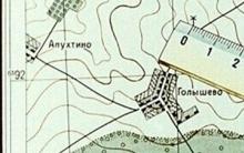
Fig. 1 Orientation of the map along the terrain line
![]()
Fig. 2 Orientation in direction
The map can be oriented:
Along terrain lines (Fig. 1);
By directions to the landmark (Fig. 2);
By compass (fig. 3).
![]()
![]()
Fig. 3. Orientation of the map by compass: a - Orientation along the line of the kilometer grid; b - orientation along the map frame
If the observer is on any linear landmark (highway or railway, power lines, etc.), then orientation is easiest to carry out along the terrain (fig. 1). For this, the map is rotated so that the image of this linear object on the map coincides with the direction of the object on the terrain and all local objects located to the right and left of the linear landmark on the map are located, respectively, on the right and left in the terrain.
Orientation of the map in the direction of a landmark (Fig. 2) is used when the location point on the map is known and from this point you can see some landmark indicated on the map.
To do this, the map is oriented so that the direction "standing point - reference point", mentally (or with the help of a ruler) oriented on the map, coincides with the corresponding direction on the ground.
Orienting the map by compass (Fig. 3) is carried out on a closed, poor landmarks. The compass is applied to one of the vertical lines of the map (to the line of the kilometer grid (Fig. 3, a) or to the map frame (Fig. 3, b)) so that the line connecting the north-south mark on the compass coincides with the selected vertical line on the map. In this case, the mark "north" on the compass should be directed towards the north (top) end of the map.
Then the karg together with the compass is turned in the horizontal plane so that the top side of the map frame coincides with the north direction of the magnetic needle, and the magnetic needle should deviate from the zero value (“north” mark) by the correction amount.
If the compass is applied to the direction of the true meridian (map frame), then the correction will be the angle of magnetic declination, if the compass is applied to the vertical grid line, then the correction is added (algebraically) from the angle of convergence of the meridians γ and the angle of magnetic declination δ.
If the correction is positive, then the compass needle should be located to the right of the "north" mark by the value of this correction, if it is negative, then to the left.
Finding your location
It is easiest to determine your point of location on the map by being near any landmark on the terrain, which is shown on the map (intersection of roads, bridge, detached tree, etc.). The location of this symbol on the map will be the desired point.
In all other cases, you can roughly determine your location in one of the following ways:
By the closest reference points to the eye (Fig. 4);
Measurement of the distance traveled (Fig. 5);
Local Subject Serif (fig. 6);
Resection (fig. 7), etc.
![]()
Fig. 4. Determination of the standing point on the map by eye according to the nearest landmarks
![]()
Fig. 5. Determination of the standing point by measuring distances
Fig. 6. Determination of the standing point by a serif on a local subject
Fig. 7. Determination of the station point by resection
The procedure for identifying landmarks and comparison of the map (scheme) with the terrain
To compare the map with the terrain means to find on the map an image of the surrounding local objects and relief elements, and vice versa - to identify the objects indicated on the map on the terrain.
When orienting on the battlefield, special attention should be paid to identifying local objects and relief details, relative to which the combat missions of the subunit are linked.
In order to find the image of the observed object on the map, you need to determine the distance to the object, and then determine the direction to the object (azimuth or angle between the known direction and the object). After that, having drawn the obtained direction on the map from the point of your position and postponing the obtained distance on the map scale, find an image of the object in this area.
To solve the inverse problem, i.e. in order to identify an object on the ground, you should:
Orient the map;
Find the point of your location;
Determine the distance to the object on the map;
Determine the directional angle and magnetic azimuth of the object and, using this data, solve the problem.
When comparing an area with a map, it is necessary not only to identify the observed local objects, but also to thoroughly understand the structure of the relief in order to use its characteristic forms and details as landmarks. To do this, it is necessary to identify the command heights and find the watershed lines, as well as to determine the relative position of the most characteristic relief elements.
After that, you need to turn to the map and identify on it the forms and details of the relief observed on the ground.


Orientation without a map
Yamal Peninsula (23 photos)
Yamal Peninsula (23 photos)
Map of Tver region Road map of Tver region detailed villages
Old topographic maps of the Tula province Old villages in the Tula region