What is scale? Scale - in the general case, the ratio of two linear dimensions. In areas of practical application, scale refers to the ratio of the size of the image to the size of the displayed object.
That is, on maps, plans, aerial or satellite images, this is the ratio of the length of the segment to its actual length on the ground. It is customary to take 1 centimeter as a unit of measurement on maps, and measure the distance in meters on the ground.
Types of indication of scales
There are three types of scale indication:
- numerical;
- named;
- linear.
Numerical scale(the most common and convenient) is a fractional scale, where the numerator is one, and the denominator is a number that shows how many times this image of the territory has been reduced (example: 1: 100,000; 1:15,000). Both figures are indicated in centimeters, which makes it impossible to make a mistake in translation, converting one unit of measurement to another. But in practice, using this scale is not convenient. Therefore, with a robot directly on the ground, the numerical scale is most often translated into a named one.
Named (or verbal) scale - a verbal indication of what distance on the ground corresponds to 1 centimeter on the map (example: 1 cm 5 km or 1 cm \u003d 500 meters). This kind of scale is understandable to the human mind, but it will be difficult to calculate and very easy to make a mistake.
There is also a third type of scale indication. This is a linear scale.
Linear scale- auxiliary measuring ruler on maps for quick measurement of distances, without calculations.
The scale of the maps is always the same at all points.
Standard scales
In Russia, standard numerical scales are adopted:
1:1 000 000
1:500 000
1:200 000
1:100 000
1:50 000
1:25 000
1:10 000.
* For special purposes, topographic maps are also created at scales of 1: 5,000 and 1: 2,000.
Converting a numeric scale to a named scale
Since the lengths of lines on the ground are usually measured in meters, and on maps and plans - in centimeters, it is most convenient to express the scales in verbal form, for example:
in one centimeter 100 meters. This corresponds to a numerical scale of 1:10 000. Since 1 meter equals 100 centimeters, the number of meters on the ground contained in 1 cm on a map can be easily determined by dividing the denominator of the numerical scale by 100. Or by 100,000 - to convert to km.
That is, the numerical scale of 1:30 000 means that 1 cm on the map is 300 meters (30 000/100).
Each card has scale- a number that shows how many centimeters on the ground correspond to one centimeter on the map.
Map scale usually indicated on it. The record 1: 100,000,000 means that if the distance between two points on the map is 1 cm, then the distance between the corresponding points of its terrain is 100,000,000 cm.
May be specified in numerical form as a fraction - numerical scale (for example, 1: 200,000). Or it can be indicated in linear form: in the form of a simple line or strip, divided into units of length (usually kilometers or miles).
The larger the scale of the map, the more detailed the elements of its content can be depicted on it, and vice versa, the smaller the scale, the more extensive space can be shown on the map sheet, but the terrain on it is depicted in less detail.
The scale is a fraction, in which the numerator is one. To determine which of the scales is larger and by how many times, recall the rule for comparing fractions with the same numerators: of two fractions with the same numerators, the larger is the one with the smaller denominator.
The ratio of the distance on the map (in centimeters) to the corresponding distance on the ground (in centimeters) is equal to the scale of the map.
How does this knowledge help us in solving math problems?
Example 1.
Consider two cards. A distance of 900 km between points A and B corresponds on one map to a distance of 3 cm. A distance of 1,500 km between points C and D corresponds to a distance of 5 cm on the other map. Let us prove that the scales of the maps are the same.
Decision.
Let's find the scale of each map.
900 km \u003d 90,000,000 cm;
the scale of the first map is: 3: 90,000,000 \u003d 1: 30,000,000.
1500 km \u003d 150,000,000 cm;
the scale of the second map is: 5: 150,000,000 \u003d 1: 30,000,000.
Answer. The scales of the maps are the same, i.e. are equal to 1: 30,000,000.
Example 2.
The scale of the map is 1: 1 000 000. Let's find the distance between points A and B on the terrain, if on the map
AB \u003d 3.42 cm?
Decision.
Let's make the equation: the ratio AB \u003d 3.42 cm on the map to the unknown distance x (in centimeters) is equal to the ratio between the same points A and B on the ground to the scale of the map:
3.42: x \u003d 1: 1,000,000;
x 1 \u003d 3.42 1 000 000;
x \u003d 3,420,000 cm \u003d 34.2 km.
Answer: the distance between points A and B on the ground is 34.2 km.
 Example 3
The scale of the map is 1: 1,000,000. The distance between points on the ground is 38.4 km. What is the distance between these points on the map?
Decision.
The ratio of the unknown distance x between points A and B on the map to the distance in centimeters between the same points A and B on the terrain is equal to the scale of the map.
38.4 km \u003d 3,840,000 cm;
x: 3,840,000 \u003d 1: 1,000,000;
x \u003d 3,840,000 1: 1,000,000 \u003d 3.84.
Answer: the distance between points A and B on the map is 3.84 cm.
Still have questions? Not sure how to solve problems?
To get help from a tutor - register.
The first lesson is free!
site, with full or partial copying of the material, a link to the source is required.
The scale can be written in numbers or words, or displayed graphically.
- Numerical.
- Named.
- Graphic.
- Linear.
- Transverse.
Numerical scale
The numerical scale is signed with numbers at the bottom of the plan or map. For example, the scale "1: 1000" means that on the plan all distances are reduced by 1000 times. 1 cm on the plan corresponds to 1000 cm on the ground, or, since 1000 cm \u003d 10 m, 1 cm on the plan corresponds to 10 m on the ground.
Named scale
The named scale of the plan or map is indicated by words. For example, it can be written "at 1 cm - 10 m".
Linear scale
It is most convenient to use the scale, depicted as a segment of a straight line, divided into equal parts, usually centimeters (Fig. 15). This scale is called linear, it is also shown at the bottom of the map or plan. Please note that when drawing a linear scale, zero is set, retreating 1 cm from the left end of the segment, and the first centimeter is divided into five parts (2 mm each).
Near each centimeter it is written what distance this corresponds to on the plan. One centimeter is divided into parts, near which it is written what distance on the map they correspond to. With a measuring compass or ruler, measure the length of any segment on the plan and, applying this segment to a linear scale, determine its length on the ground.
Knowing the scale, you can determine the distances between geographic objects, measure the objects themselves.
If the distance from the road to the river on a plan with a scale of 1: 1000 ("in 1 cm - 10 m") is 3 cm, then on the ground it is equal to 30 m. Material from the site
Suppose, from one object to another 780 m. It is impossible to show this distance in full size on paper, so you have to draw it to scale. For example, if all distances are shown 10,000 times smaller than in reality, that is, 1 cm on paper will correspond to 10,000 cm (or 100 m) on the ground. Then, on the scale, the distance from one object to another in our example will be equal to 7 cm and 8 mm.
Pictures (photos, drawings)
On this page material on topics:
Scale theme
Lesson preparation materials
T.V. Konstantinova
Cand. ped. sciences, senior lecturer
E.A. Kuznetsova
Kaluga State Pedagogical University
them. K.E. Tsiolkovsky
Means of education
A plan of the area (preferably of its own area), a physical map of the hemispheres, a physical map of Russia, measuring instruments (measuring tape, rangefinder).
Terms and concepts
Scale (from German - measure and Stab - stick) -
the ratio of the length of a segment on a map, plan, aerial or satellite image to its actual length on the ground.
Numerical scale - scale, expressed as a fraction, where the numerator is one, and the denominator is a number that shows how many times the image is reduced.
Named (verbal) scale -type of scale, verbal indication of what distance on the ground corresponds to 1 cm on the map, plan, photograph.
Linear scale - auxiliary measuring ruler applied to maps to facilitate measurement of distances.
Geographical sciences and professions of geographers
Geodesy (Greek - land division) - the science that studies the shape and size of the Earth, methods of measuring distances, angles and heights
on the earth's surface.
Topography (Greek - place and - write) - a section of geodesy dedicated to measurements on the ground for creating maps and plans.
Cartography-
the science of maps, their creation and use. Cartography also studies globes, plans and other images of the earth's surface, in addition, maps and globes of the starry sky and other planets.
Geographer's toolkit
The measuring compass is a tool for transferring dimensions to drawings. When working with geographical maps, it is used to determine the distances between points, individual parts of the map.
Curvimeter - a mechanical portable device designed to measure the lengths of winding lines from maps. It consists of a round box with a dial and an arrow, a small wheel at the bottom. The divisions on the dial scale can mean the path traversed by the wheel on the map (in cm), or immediately show the distance on the ground, depending on the map scale.
Rangefinders -devices of various types, used to determine distances without directly measuring them with a measuring tape or tape measure.
Measuring tape -the main tool used to measure distances before the invention of rangefinders. It is a steel tape, usually 20 m long, fixed to the ground with long (about 0.5 m) steel pins.
Geographic nomenclature
Local names: settlement where students live, streets, shops, educational institutions, nearby bodies of water, various local landforms, etc.
Independent work of students
Determining distances from maps using a scale
Purpose of work: formation of skills to work with different types of scales; the formation of skills to determine distances on maps using a scale.
Equipment: a geography atlas for the 6th grade, a curvimeter or thread about 20 cm long, a workbook.
Exercise 1. Convert the numerical scale of the map to the named one:
a) 1: 200,000
b) 1: 10,000,000
c) 1: 25,000
Rule for students. For an easier conversion of a numerical scale to a named scale, you need to calculate how many zeros the number in the denominator ends in. For example, on a scale of 1: 500,000, there are five zeros in the denominator after 5.
If after the number in the denominator is five
and more zeros, then, covering (with your finger, a fountain pen or simply crossing out) five zeros, we get the number of kilometers on the ground, corresponding to 1 centimeter on the map. An example for a scale of 1: 500,000. The denominator after the number is five
zeros, closing them, we get for the named scale: 1 cm on the map 5 kilometers on the ground.
If after the digit in the denominator there are less than five zeros, then, covering two zeros, we get the number of meters on the ground, corresponding to 1 centimeter on the map. If, for example, in the denominator of a scale of 1: 10,000 we close two zeros, we get: in 1 cm - 100 m.
Answer:
a) 1 cm - 2 km; b) 1 cm - 100 km; c) 1 cm - 250 m.
Task 2. Convert the named scale to numeric:
a) in 1 cm - 500 m
b) 1 cm - 10 km
c) 1 cm - 250 km
Rule for students. For an easier translation of a named scale into a numerical one, you need to convert the distance on the terrain indicated in the named scale to centimeters. If the distance on the ground is expressed in meters, to get the denominator of the numerical scale, you need to assign two zeros, if in kilometers, then five zeros.
For example, for a named scale of 1 cm - 100 m, the distance on the terrain is expressed in meters, therefore, for a numerical scale, we assign two zeros and get: 1: 10,000. For a scale of 1 cm - 5 km, we assign five zeros to a five and get: 1 : 500,000.
Answers:
a) 1: 50,000; b) 1: 1,000,000; c) 1: 25,000,000.
Task 3. Determine the distance between points on the physical map of Russia in the 6th grade atlas:
a) Moscow and Murmansk
b) Mount Narodnaya (Ural Mountains) and Mount Belukha (Altai Mountains)
c) Cape Dezhnev (Chukotka Peninsula) and Cape Lopatka (Kamchatka Peninsula)
Rule for students. When determining the distance on the map between points, you should:
1. Measure with a ruler the distance in centimeters between points. For example, the distance between the cities of Moscow and Astrakhan on the map is 6.5 cm.
2. Find out by the named scale how many kilometers (meters) on the terrain corresponds to 1 cm on the map.
(On the physical map of Russia in the geographical atlas of the 6th class, 1 cm on the map corresponds to 200 km on the ground.)
3. The distance between points measured with a ruler multiplied by the number of kilometers (meters) on the terrain for a given scale.
6.5 x 200 \u003d 1300 km.
Answers: a) 1460 km; b) 2240 km; c) 2500 km * * .
Task 4. Measure the length of rivers on a physical map of Russia in a 6th grade atlas:
a) Oka;
b) the Ural river;
c) Kama.
Measurements of winding lines on the map (in this case, rivers) are carried out using a curvimeter or a thread.
How to measure the length of a river with a string (student rule).
1. The thread must be moistened, otherwise it is difficult to lay it on the paper.
2. Attach the thread to the curved line (to the river - from source to mouth) so that it repeats all the bends of the river.
3. Mark on the thread (with your fingers or tweezers) the source and mouth points (you can carefully cut the thread with scissors at these points).
4. Straighten the thread, attach the noticed (or cut) section of the thread to the ruler and measure how many centimeters it contains. The measurement result is multiplied by the number of kilometers on the ground for a given scale. (You can attach a string to a linear scale on a map and read the length of the river right away.)
Answers:
a) about 920 km; b) about 1300 km; c) about 1200 km.
Note.The accuracy of measurements of curvilinear sections is low, so the students' answers may differ somewhat from the answers of their comrades. Surely, the results of measuring with a thread on a small-scale map will be STRONGLY different from the river lengths indicated in textbooks and reference books. The current length of the Oka is 1500 km, the Ural is 2400 km, the Kama is 1800 km. It is imperative to tell the students these numbers so that the "clumsy" numbers of independent measurement are not fixed in their memory (and they have a great chance of gaining a foothold precisely because they were obtained independently). It is also necessary to explain where this discrepancy comes from: a lot of medium and small turns, river bends, a small-scale map cannot reflect, they are all "straightened". This explanation will come in handy in the Scale topic: it will make it easier to understand the differences between maps of different scales.
Figures and facts
Scales of topographic maps
| Numerical scale | Name cards |
1 cm on the map corresponds on the ground distance |
1 cm 2 on the map corresponds to on the ground squares |
|---|---|---|---|
| 1: 5 000 1: 10 000 1: 25 000 1: 50 000 1: 100 000 1: 200 000 1: 500 000 lll 1: 1 000 000 |
Five thousandth Ten thousandth Twenty-five thousandth Fifty thousandth One hundred thousandth Two hundred thousandth Five hundred thousandth, or half a million Millionth |
50 m 100 m 250 m 500 m 0.6 miles 2 km 5 km lll 10 km |
0.25 ha 1 ha 6.25 ha 25 ha 0.6 miles 2 4 km 2 25 km 2 ll 100 km 2 |
The cards have other names as well. Let's define what scales the following names refer to: hundred-meter, half-kilometer, kilometer, two-kilometer, five-kilometer, ten-kilometer.
What kind of scale are the names given in the table based on? What about those in the previous paragraph?
(student reading)
A story about a 1: 1 scale map
Once upon a time there was a Capricious King. Once he traveled around his kingdom and saw how great and beautiful his land is. He saw winding rivers, huge lakes, high mountains and wonderful cities. He became proud of his possessions and wanted the whole world to know about them. And so, the Capricious King ordered the cartographers to create a map of the kingdom. The cartographers worked for a whole year and, finally, presented the King with a wonderful map, on which all mountain ranges, large cities and large lakes and rivers were indicated.
However, the Capricious King was displeased. He wanted to see on the map not only the outlines of mountain ranges, but also the image of each mountain peak. Not only large cities, but also small towns and villages. He wanted to see small rivers flowing into rivers.
The cartographers got to work again, worked for many years, and drew another map, twice the size of the previous one. But now the King wished that the passes between mountain peaks, small lakes in the forests, streams, peasant houses on the outskirts of the villages were visible on the map. Cartographers drew more and more new maps.
The capricious King died without waiting for the end of the work. The heirs, one after another, ascended the throne and died in turn, and the map was all drawn up and drawn up. Each king hired new cartographers to map the kingdom, but each time he was dissatisfied with the fruits of labor, finding the map insufficiently detailed.
Finally, the cartographers drew an incredible map. The map depicted the entire kingdom in great detail - and was exactly the same size as the kingdom itself. Now no one could find the difference between the map and the kingdom.
Where were the Capricious Kings going to keep their wonderful map? The casket for such a card is not enough. You will need a huge room like a hangar, and in it the map will lie in many layers. Only is such a card needed? After all, a life-size map can be successfully replaced by the terrain itself.
Dependence of map detail on scale
If you have ever flown airplanes, then you probably remember how at the beginning of the flight, when the plane just takes off from the ground, the outlines of the airport, houses, squares float under it. But the higher it rises in the air, the less details are visible through the window, but the wider the space that opens up to the eye becomes. The detail of the maps also changes when the scale is reduced.
On large-scale maps, where no more than 500 m of the earth's space can fit in 1 cm of area, a small area is depicted in great detail.
On small-scale maps, where 1 cm fits up to several thousand kilometers, huge areas of the Earth are shown, but with little detail. Both cards are needed, depending on their purpose.
If you are wondering which countries you will fly over, going from Moscow to Melbourne, you need to open a small-scale map, and when going into the forest to pick mushrooms or on a hike with friends, you need to take a large-scale map with you so as not to get lost.
Homework for those who wish
Define the scale of the maps of your area
Find maps depicting the area you live in. If there are no such maps at home, ask friends and acquaintances, a geography teacher, a librarian or a bookstore seller for help.
Write down the scale of the maps showing your area. Which scale is larger, which is smaller?
Compare maps of different scales and find out on which maps the larger area is depicted, on which - the smaller one.
Determine on which maps the terrain is depicted in more detail, on which - less detailed.
Make a conclusion about how the area of \u200b\u200bthe depicted territory and its detail depend on the scale of the map.
Find your location on the map
Using the map of your region (region, republic ...), determine the distance from your settlement to the regional (regional, republican) center, if you do not live in it, or to any other settlement, if you are in the center of the region ( territories, republics).
On old maps, the named scale could show how much distance on the ground corresponds to one inch or another archaic linear measure on the map.
Hereinafter, the calculations were made according to the atlas “Geography. Initial course. 6 cl. ": Atlas. - M .: Bustard; DIK Publishing House, 1999. - 32 p. Of course, at this stage of training, the teacher does not yet touch upon the issues of distortion of distances associated with cartographic projection.


Orientation without a map
Yamal Peninsula (23 photos)
Yamal Peninsula (23 photos)
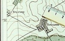
Map of Tver region Road map of Tver region detailed villages
Old topographic maps of the Tula province Old villages in the Tula region